
(Gauchos at Valle Fertil)
Finally leaving Mendoza, seemed almost surreal. We had only spent a few days here this time, but over all, we spent nearly a quarter of our time in South America here so far. But now it was time to head north. The general idea was to hit some of the tourist spots on the way to the border of Bolivia, pretty much straight north. Due to the weather, we weren't really in the mood to cross the Andes into Chile and do the Atacama or Uyuni circuit which is so popular with the tourists.
On the way we wanted to have a look at the "Valle de la Luna" and "Cerro de los Siete Colores", but other than that we didn't have a plan (as usual).

(Near Valle Fertil)
Our first day brought us to a place called San Augustine del Valle Fertil, which is basically an oasis in the desert. The fertil part is supplied by a lake and the fact that they have a river which has water all year, but other than that they are pretty much in the middle of the desert. We spent a couple of days here as there was a festival and some "sights" to see. The festival was in honor of San Augustine, and the most interesting part was the blessing of the gauchos. A whole troupe of which had shown up from the outlying haciendas and small pueblos. They paraded around on their horses, and were blessed by the minister. The tourist sights around here included some petroglyphs and a few depressions in rocks which the indians used to grind flour. Nevertheless it was a nice little walk through some of the valley. After this we headed to Valle de la Luna, a national park just north of here.

(Valle de la Luna, NP)
Valle de la Luna (also known as Ischigualasto) has some of the oldest geological formations and dinosaur remains on the planet. Together with the Talampaya National park further north this is a Unesco world heritage site. The Triassic period is extremely well preserved here, and gives geologists a very good insight into the state of the planet at that time. To me the name is a misnomer, but apparently some people think that some parts of the park resemble moonscape. Nevertheless, there are some wonderful colors and rock sights here. The museum was "cute", but interesting nevertheless. All in all worth the small entry fee.
A bit further north is the Talampaya national park. Unfortunately we decided to skip it. Mostly because like Valle de la Luna, you are not allowed to wander around freely, and have to take a tour. In this case they wanted A$ 20.00/person, plus A$45.00/person for the tour, and a trivial amount to camp. From the brochure that we saw, it is basically a canyon trip with various rock formation along the route. So we decided to skip it. In the case of Valle de la Luna it was only A$30.00 for us both, and we could at least drive our own vehicle. In Argentina there have been a number of such parks, and to date we have pretty much boycotted them all. I am not even going to get into the fact that they charge tourists at least double the rate that they charge locals. In the end we camped for free a few kilometers further up the road at a YPF Gas station (in the rural part of Argentina there are lots of these Gas stations which allow you to camp and use their facilities, and are set up for this, with tables, and grill places).

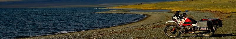
(Laguna Blanca)
The following day we had another highlight, by going over a great pass, with some awesome rock formations and beautiful colors everywhere. Cuesta de Miranda between Vila Union and Sembradio is absolutely spectacular. The road is dirt and very tight, but has some spectacular vistas on either side of the pass, well worth a look if you are in the area (ok, it is pretty far from anything else, but it was worth it). The day ended in a place called Belen, where we spent a couple of hours trying to camp, with no luck. The camping was open but there was no-one there, and in the end we gave up and went to a cheap hotel in town. The reason for coming here was an Archeological museum and Inka ruins in nearby Londres.

(Inca Ruins, Londres)
We spent two days here, checking out the museum and the Inka ruins. There turned out to be two places to see artifacts exhibited. The first was the tourist hotel/complex (which we did not stay in, as it much too expensive for us), the second was the regional museum. There were lots of interesting things displayed, funeral urns, jewelry and lots of every day items. In Londres the Inka ruins were interesting, and in particular the small museum attached to the whole thing. The lady there gives you a very good explanation of their history and culture, and there are a lot of very interesting artifacts. The site itself requires lots of imagination (the model in the museum helped), but was definitely worth the effort.

(Antofogasta de la Sierra)
From Belen we headed north on a route which turned out to be the hardest we had done so far, and which went through the most scenic part of Argentina, and that is saying something. The RP43/RP17 which goes north from Belen through Antofogasta de la Sierra up to San Antonio de los Cobres is very rough in places, and when we went through it was bitter cold and windy, making it even tougher for us. There is basically nothing here but volcanoes, rocks, sand, mountains, and a few Vicunas (a type of Llama), but the vistas are out of this world. The whole area runs along the border to Chile and lies on the lee side of the Andes mountains. The whole plateau is at an altitude of between 2500 and 4000 meters (with temperatures around 2C and winds of 100km). The colors of the mountains changed by the minute and if we weren't freezing so much we might have spent a lot more time admiring them. We camped wild at the foot of some hills, and this is one of the few times that the Hilleberg tent had a chance to show its strengths. Although the wind was howling the tent went up in a few minutes, and stayed rock steady throughout. Of course everything was covered in blowing sand, but hey that is life on the road.

(On the road to Antofogasta de la Sierra)
The following day we made it to Antofogasta de la Sierra, which lies at approx. 3800m and is flanked by two volcanoes. As luck would have it when we got there there was of course no more gasoline to be had. We planned to spend the night anyway, but in the end it turned out to be three days before a truck made it through with gasoline. Apparently the truck with the fuel could not make it because of the wind!! Anyway we used the time to check out the Antofogasta volcano, which we climbed late in the afternoon when the wind seemed to have died out a little (not really, it almost blew us off the mountain). We also enjoyed a Mineral museum by a local artist. The gentleman has spent around 16 years collecting rocks and other interesting stuff from the area around here. Together with his son they polish and work the minerals into jewelry and other stuff (statues, etc.) All in all very worthwhile.

(On the road to San Antonio de los Cobres)
In due order we got our gasoline and were able to continue. The road from here north was the worst so far (by the way before Antofogasta we were aghast to find a perfectly paved road for more than 100km in the middle of nowhere!!). But if anything the area was even more scenic than before, but still bitter cold and windy. The road goes through a placed called El Salar del Hombre Muerto (Dead Man's salt flat), shortly thereafter, it becomes a wide dirt road made the mining company which is active in the area. So the road did not improve as the big trucks make huge holes and ruts making it a job just to get through without crashing. By the time we made it to San Antonio de los Cobres we were in the early stages of hypothermia, it was that cold!! There isn't much to this town, but we found a little hostel, which charged and outrageous price for what they provided (La Posta de los Andes), but it was nevertheless the cheapest in town. (under any other circumstances I would just have camped!!) There was actually a tourist complex here which was charging over 60 US$ for rooms, unbelievable. We just crawled into bed and tried to warm up as fast as possible. With our sleeping bags and their heavy wool covers we managed to get warm after a while.
The following day we made it down the from the mountains to Salta. The road is pretty spectacular nevertheless, coming through a huge valley before it opens up into the plains where Salta lies. There were so many mountains, with so many colors that we decided not to even bother with going to the Cerro de los Siete colores which lies norht of Salta.

(Humitas and Empanadas)
Salta, is an old colonial town, with some very nice architecture. We spent a few days sightseeing and recovering from our ordeal in the mountains. Eating, empanadas, tamales and humitas, all of which have a national reputation to recover our strength. Empanadas are pastries filled with meat, chicken, ham and cheese or some other mixture and baked. Tamales are a mixture spices, mashed corn and a piece of meat, wrapped in corn leaves and boiled. Humitas are similar but have a different shape and contain egg and ham, also wrapped in corn leaves and boiled.

(Main square, Salta)
In addition, to relaxing and recovering, I also had to weld a broken frame on the bike. I guess one of our crashes did a little more damaged than I would have liked. Overall though it was one of the highlights of the trip so far. We just wish that it hadn't been so cold and windy. I hope some of the pictures give a good impression of what we saw.
No comments:
Post a Comment