Wednesday, October 15, 2008

Peru, Puno to Arequipa and the Peruvian Altiplano


(Lake Titicaca from the Peruvian side)

Another day, another country.

To my surprise it turns out that the customs people required an insurance policy on the bike. Unfortunately, they did not accept any of my papers as being a valid insurance. Ok, might be because I don't have a valid insurance (at least not for this part of the world). Well, luckily for me, the customs officer was rather lenient and allowed me to enter the country with my bike anyway. So after a while we were finally in Peru.

The road followed Lake Titicaca and to our surprise was much move scenic and more interesting than the Bolivian side. In particular since on this side there is both a lot more to see and it follows the coast for a lot longer. On this side there was also a lot of more of the typical reed beds which is typical of this lake. Puno like Copacaba on the Bolivian side are the major points of embarkation for people taking cruises on the lake or visiting the islands (floating or not). As such they are similar in the tourist infrastructure (Puno being much larger of course). Having already spent a week on the lake, and not planning on doing any excursions, we just spent the night. Nevertheless, we found Puno to be pretty nice. The usual plaza and church, some interesting architecture, and plenty of tourist shops.

The best thing about such towns from our point of view is that we can spent a lot of money quickly as the prices are always higher than in non-tourist areas. Ok, maybe this is not really the "best" thing. That being the fact that we can sometimes find stuff which we don't get anywhere else. In the case of Puno, we found a bakery which had excellent bread, and croissants. Not only that but they had some smoked ham and Philadelphia cream cheese, and lots of really great desserts, including a good cheesecake. Can't always save money! So next time you are in Puno, don't forget to stop by Rico Pan. Oh, and while you are at it, don't forget to enjoy the free pisco sours at happy hour. If you are really a cheap skate, you can go from bar to bar and get a free pisco sour at each one, without actually spending any money on the next drink. Most bars offer the first drink free, followed by 2 for 1 for the following drink.

Continuing from Puno we headed to Arequipa. The road passed through a town called Juanica, which for my money wins the prize for one of the most chaotic towns we have been through in South America, regardless of size. Luckily for us things looked up once we made it through. The road goes up over 4500 meters before coming down again. For the most part the road is excellent and is extremely curvy at both ends (the middle part being pretty straight and boring). The Altiplano here has plenty of canyons, mountains, volcanoes and even a huge lake at the top. This being a major north south artery it had its share of traffic, in particular plenty of trucks and buses, but the views were worth it.
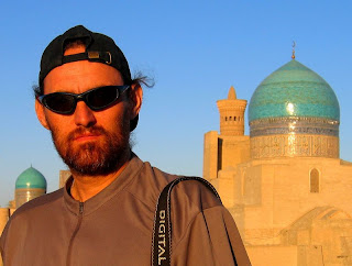

(Arequipa, Peru)

Arequipa is Peru's second largest city and this was immediately believable as its suburbs stretched for kilometers before getting near town. The town lies along a valley flanked by a large volcano and mountains to the north. The town is another tourist magnet with lots of churches and monasteries, and the usual palette of tourist offerings in the mountains and canyons nearby. Particularly impressive is the main square, with a huge cathedral on one side which takes up the whole width of the block. Behind the cathedral the volcano presides over the whole town and valley. Cobblestone streets and lots and lots of hispanic architecture complete the picture. One thing that stands out are the white stone blocks which make up most of the building in the old part of town. All the old building have large open courtyards, and a whole maze of passages, corners, stairs (although buildings are only 2 or 3 floors, due to frequent earthquakes).

To our surprise the first day we got here, there was a food festival in a park near our hotel. This was an opportunity we could not pass up, so we spent the whole day, sitting in the park and trying the various specialties on offer. This included stuff like Cuy (Guinea pig), stuffed peppers, rice with duck, and chicharron (fried pork). Check out the pics below!


Chicharon de chancho, Rocoto relleno, pastel de papa, arroz blanco, aji de habas, zarza de pata


Arroz con Pato


Albondigas, salsa de anchoeta, guiso de habas


pepiche de cuy (guinea pig)


crochetas de atun


pure de arvejas, chuño relleno de alpaca y higado de cuy, suffle de verduras con anchoas


torta bicolor, pie de manzana, crema de fresas

In addition to the great architecture and all the monasteries and churches, there are some very interesting museums. In particular, the university museum here has the frozen mummy of Juanita. An inca maiden who was sacrificed on the nearby volcano. This is the 4th or 5th mummy of this type we have seen. (The others being in the museum in Salta). All of them fascinating if a bit macabre. Katheryna visited the St. Catalina monastery and found it extremely fascinating. Not only the architecture but also the lifestyle of the nuns there turns out to be really fascinating. The nuns being the daughters of wealthy noblemen were allowed to live a very luxurious cloistered life, basically in the style to which they were accustomed, regardless of the fact that they now "served" God. Their quarters, reflected the riches which they were allowed to keep in their monastic life. After a couple of hundred years of this "lax" living, the pope finally sent a mother superior who clamped down and enforced a simpler lifestyle with less luxury.


(Plaza de Armas, Arequipa, Peru)

The plan is to continue south to the coast. Although we might be taking a little side trip to see Colca canyon near here, which is the "deepest" canyon in the world. Even deeper than the Grand Canyon apparently. After that we will check our Nazca and then back into the mountains to Cusco and Machu Pichu. But of course with us, one never knows. Too much planning is not our style.


Technorati Tags: , , , , , ,

Bolivia, a lot to see.


(Potosi, and Cerro Rico)

After finally getting our gas we headed to Potosi. The roads head up into the mountains and pretty much stay up there. I found it amazing that the trucks and buses make it at all. The route is in really bad shape, and is pretty dangerous to boot. But there you are, people and goods have to be moved around. We made it to Potosi without any problems, other than some heavy wear and tear on the bike, but as I mentioned, it is nothing compared to what cars, trucks and buses have to deal with. Oh, and to prove it, every few km's there was a truck, car, or bus stranded. Sometimes with people working on it, other times, just abandoned there.

On the good side, the ride is very scenic, and goes through lots of little villages. One curious thing, is we found that in some parts the road was suddenly paved and in excellent shape, this would usually last a few km's and then suddenly we are back to some bone jarring rock and sand stretches. On one such stretch we even encountered an accident which killed the two inhabitants of the vehicle. Apparently, they had blown a tire while driving much too fast and lost control of the car, one passenger was thrown free of the car and was lying in the middle of the road. The other lost their life when the car was crushed like an accordion. So there is one thing to be said for bad roads, they keep the vehicle speed down.


(Traditional dancers, Potosi)

The final few km's to Potosi was on a great road, which is good, considering that the altitute is over 4000 meters, and at this hight my bike doesn't have too much power. Potosi and the area around is of course the center of mining activity in Bolivia. For over 500 years they have been pulling silver out of the hills and mountains around here. In particular Cerro Rico, which although heavily mined for all this time, apparently still has more silver in it than they have pulled out. Potosi is also the highest city in the world, and is spread out at the foot of Cerro Rico. In typical Mining town fasion, the streets are narrow, steep, slippery, and very confusing, with the usual South American love for one way streets and lack of signalization.


(Corn soup heated by hot rocks!, check out this link for a complete desc.)

Potosi turned out to be a shock for us, it has been a long time since we have seen this many tourists. I guess it is something that we are going to have to start getting used to. Nevertheless, the town itself is very traditional if you get a few blocks away from the central plaza and the pedestrian zone which accompanies it. We spent a few days here walking around, checking out the many churches and some museums. The museum we visited was fascination, Casa de la Plata, This museum is in a fantastic building which used to the mint where, coins where made with the silver dug out of Cerro Rico. It is a very interesting museum, with some great original machinery used over the centuries to work the metal. One of my favorite displays was a single commemorative silver coin from the treasure of Nuestra Senora de Atocha. If you know the story, this Treasure ship went down in a storm off the coast of Florida. Of course the joke is that the silver recovered from the Atocha came from here, and all they have to show for it was this one commemorative coin sent back.

From Potosi we headed to Uyuni as the political problems on which I have already reported have not eased up enough to allow us to go north. For example, according to all the information that we could gather, there wasn't any gas to be had in that direction. Anyway, this gave us a chance to go and have a look at the Salar de Uyuni, the largest Salt Flats in the world. So that is what we did. The road was pretty difficult, made worse by the fact that it was pretty much all under construction. On the up side it was a very scenic road. There isn't much but a few mining towns, plenty of sheep, and a some very beautiful vistas. If it hadn't been such a bad road we would have really enjoyed the ride. Tired and dusty we made it to Uyuni.


(Train graveyard, Uyuni)

Uyuni turned out to be really nice. A dusty, windy, rugged outpost of civilization in the middle of nowhere. Nevertheless it is another stop on the "Gringo" trail, so the town is full of tour bureaus and the usual tourist infrastructure. From here people book tours of the Salar and the lagoons along the border to Chile. We skipped the lagoons but headed to the Salar.


(Uyuni Salar)

The Salar is a huge expanse of white with a few islands here and there. The whole area is dominated by a volcano on the north shore. The Salar is criss crossed by tracks used by cars crossing the Salar. They stand out like veins and although you can drive/ride pretty much anywhere, in some places you are better off if you keep to the tracks. The reason being that in places, in particular near the edges, there is a thin crust of salt, below which is usually water. As a matter of fact in a number of places near the edge, water is bubbling up through the salt, making what they call the Ojos del Sala (eyes of the Salar). We spent a couple of days riding around and camping out on the sand. One thing I learnt about camping on Salt is that it is harder than steel. I pretty much bent all my special tent stakes putting up my tent. The thing which I will remember about the night on the Salar is the night sky. With no light or towns nearby, and the added plus of no clouds, you could imagine that you were floating in the middle in the stars. Unforgettable.


(The road to Huari)

From the Salar we headed north around the volcano through some spectacular scenery, volcano on one side, salar on the other. We met some really nice people with whom we had some interesting conversations. In particular regarding the political situation, which is on everyone's mind. Now we got some perspective from the local farmers point of view. Apparently they are really happy with Morales, and are expecting a lot of the government. They feel that the Civic Committees are being very unfair in their demands. It definitely seems that the government has their hands full keeping the subsistence farmers happy, if they loose that base then they will be in serious trouble. One example is that a couple of the people we talked to who raise Quinoa (a widely grown grain in this region), said that the government "owed" them a tractor, which they had been promised during the election time!


(On the road Huari)

Again, the road we took north towards Oruro was under construction. A new record for the worst road went to this stretch. Nothing but deep dust and sand. We found out that all the road building was due to the fact that they were going to be building a new airport in Uyuni and wanted to have some decent access roads. Well, they aren't there yet! In Huari, we met an Austrian couple on KLR (Kawasaki), and a Swiss guy on a XT600 (Yamaha). We spent a nice evening talking about riding and traveling. It has been a while since we had met fellow bikers.


(A festival, Oruro)

Oruro is another mining town. Some interesting museums, but not much else. Unlike some of the other towns, it doesn't really have very nice "old" town. A lot less touristy than Potosi, but there were still plenty of tourist around. Here we visited the mining and folklore museum, as well as the Archeological museum, both of which were interesting. In particular the mining museum, where we went into a mine shaft, and got to spent some time talking with an ex-miner. He provided a lot of valuable information and first person account of how the whole mining system works in Bolivia. The salient points are that, most of the mining is done by co-operatives, which are responsible for the sale of the mineral, but little else. Mining is still done by these people in the same way as it was for hundreds of years. The main reason is financial, they simply don't have the money for proper equipment and safety gear. So rather than using masks to avoid lung problems, they chew cocoa leaves and use breath through the mouth. The cocoa leaves serve both as a stimulant and as an air filter!!


(Getting on a ferry, Lake Titicaca, Bolivia)

Continuing on, we headed to La Paz and then to Copacabana on lake Titicaca. La Paz is a huge city, and very steeply built. It lies in a river valley (or canyon) and has grown up and along all sides. Horrible traffic and steep, very steep hills. We were happy to just spent a single night here before continuing on to Copacabana, which lies on lake Titicaca and is just on the border to Peru. The town is another very popular tourist destination. People come here to do cruises on the lake, and visit various islands. I really enjoyed the road along the lake and all the small towns. As with most lakes it is pretty scenic but other than the altitude and the fact that it is lake Titicaca there is not much to differentiate it from other lakes. Ok, maybe the reed boats that are on display in some of the villages we rode through does differentiate it a bit. But not much.


(Lake Titicaca and Copacabana, Bolivia)

After a few days here we moved on to Peru, and the story continues.


Technorati Tags: , ,

Boilvia, Tarija, Pando, Santa Cruz, A civil war brewing??


(Between Tarija and Potosi)

It has now been a week since we got here. We "can't" leave because we haven't been able to get gasoline. Well, actually we can leave, as I have enough gas to get back to the border of Argentina, but of course we are interested in going into Bolivia. As you might have read previously the plan had been to head to Trinidad. Unfortunately Trinidad, which lies around 1300km north of here is in the middle of the Santa Cruz province, which along with a couple of others (in particular Pando), is in the middle of some serious civil un-rest.

The problems which the border police had mentioned to us on entering were fairly new, and had just started a day or so previous to our entry, at least as far as Tarija was concerned (the name of the province as well as it's capital). But further north and north/west problems had been brewing longer (around 3 weeks apparently). All in all there seems to be 4 provinces in which there are blockades, and general unrest.


(Between Tarija and Potosi)

The players are, on one side the central government out of La Paz, on the other so called Civic Committees, which to a great extent are the local government(s), and finally the farmers which support the government, and are mobilized by them, against the Civic Committees. Of course the Civic Committees also represent the farmers. But unlike the central government, which subsides (some would say buy) the farmers, the Civic Committees is committed to improve the general situation of everyone, at least that what they keep insisting.

In Pando over the weekend there was a massacre where members of the Civic Committee allegedly shot women and children with the police just standing by. At least if you believe some of the news reports. Some of the people I have talked to say that the government armed, or is arming, the farmers to go against the Civic Committees. Regardless of which side you believe, the "facts" seem to be that a number of people were killed. Of course tactically it is totally understandable that the government prefers to use farmers than it's own military or police organs against the "uprising".

Here in Tarija the situation isn't as bad. There were some serious unrest the day previous to our arrival, and the first few days we were here, but everything seems to have settled down. This in the wake of various discussions that the Civic Committees from Tarija and Santa Cruz were having with the government. Also, possibly due to the religious festival which was taking place during the last week or so. In case you are curious about, when I say unrest, what I am talking about is blocking roads, burning tires and such, throwing rocks and general destruction of property and the looting which always seems to accompany such things. At street level, there are protesters on one side (Civic Committees), police and or peasants on the other. As long as no-one moves there is no problem, everyone respects the blockade and there is no violence. But when one side or the other gets too close then all hell breaks loose. Most of the time, it seems to me that young people are looking for excuses to destroy something, and do some looting, and provoke a confrontation. In some cases the Police steps in and grabs a demonstrator or looter, only to be violently set upon by both sides. A bit curious if you ask me.


(Potosi)

The Civic Committees are supported by a large number of the populace, in particular, the middle class. Most of the various government agencies, all of which are closed, with the employees standing around outside the offices, also seem to be supporting the Civic Committee. At least as far as we can tell. All around Tarija, you see stickers with the logo "Si a la Autonomia". Which is pretty self-explanatory.

The core of the problem as far as we have gathered is that the government wants more taxes collected on the resources produced by the various provinces. At the same time they are reducing the government expenditures in these same provinces. The Civic Committees are arguing that the government is not investing in infrastructure projects in the region, an are only taking the money out. Specifically, road building, this being one of the core infrastructure items which is necessary for the development of the country.

The solution they are seeking is more Political Autonomy. A greater say in how the resources are distributed. The feeling of the people (to whom I have spoken) is that the government is mismanaging the wealth of the nation by using it to maintain "their" hold on power. The words Narcotrafficantes and Communists is bandied about a lot when describing the government. The latest example of government mis-management, was a recent referendum which was held on Evo Morales. Apparently, the agency which was in charge of the voting, rigged it by ballot stuffing, going so far as to register and casting votes on behalf of a number of people which at the time were deceased (and still are for that matter..).

On the government side, they are accusing the provinces of trying to usurp presidential power. This as a result of having lost the elections, and the various referendums. In addition they are also accusing the opposition of refusing to sit down and talk, electing instead, civil unrest. Not to mention being greedy. When the president came on tv he threw around some number and the one that stayed with me was that the per capita income in Tarija was around 7000B$ whereas in La Paz it was only around 300B$. On tv there are a lot of ads from both sides.

As I write this (18.09.08), all the blockades have been lifted both in Santa Cruz and in Tarija, the Civic Committees are in discussion with the central government in Cochabamba, and joy of joys, today the Gasoline arrived. I stood in line for 1 1/2 hours to get a tank full of gas (at around 0.40$ a liter). The situation in Pando remains very tense, as the government has arrested district chief (illegally some say), but the rest of the country seems to be getting back to normal.


(Potosi)

We are dropping our plans to head to Trinidad, and instead will head towards Potosi and then possibly the Salars near the border of Chile before heading back north towards La Paz and eventually Peru. We are not really worried about the civil problems, because unlike in other parts of the world, the issues here are strictly internal, and there is no movement against foreigners (the U.S. ambassador being a notable exception; he was kicked out of the country by the president for siding with the Civic Committees a few days back).


(Potosi)

As you can imagine there is a lot more stuff going on, only some of which we notice or get to hear about. But one thing that the populace has been laughing about is the antics of Hugo Chavez, the president of Venezuela. Apparently at the hight of the tensions he threatened to come in (militarily) in defense of Evo Morales. He said that he would not tolerate it if anything happened to Evo. This of course brought out the nationalism in everyone, including Evo Morales, all of whom condemned the statements. The people on the street seem to have taken this as another proof, that the "Narcotrafficantes" are sticking together to stay in power...


Technorati Tags: , , , ,

Bolivia, The Saints come marching in; The Festival of San Roque, Tarija


(Iglesia St. Roque, and procession)

San Roque the patron Saint of Tarija is celebrated for a week ending on the 16th of September. We were lucky enough to catch the last few days of the festival. Below you will see a few of the pictures we took during this time.


(Katheryna in the middle of things)

The festival (at least from our point of view) consists of daily parades of "Chunchos", preceding the Saint as he is paraded through the town. This is a very colorful and noisy procession, as the "Chunchos" are accompanied by drums and a couple of wind instruments. First a short single reed flute (not the andean multi-reed flute, but similar sounding), a short and very shrill sounding thing. In addition something which to me looked like the South American version of an Alp horn, though much lighter, as each musician carried his in the air while playing it. The instrument is called "La Caña", and is basically a long hollow tube, topped by a "horn", and doesn't have much of a sound, just a low hollow bass rumble, more or less. Unfortunately, the music, is very monotone, there is little variation, as there is only a basic rhythm with few notes, and after a few hours of this, you pretty much have had enough.


(The idol being paraded through town)

Some background on the San Roque festivities:
In 1875 "San Roque" "appeared" here in Tarija, Boliva (548 years after his death in Europe) and apparently his apparition healed a number of people of Leprosy. San Roque was himself miraculously cured of the plague in Italy. After having healed a number of people of the plague, he himself was afflicted, and kept alive by a dog while living in a cave, after having been expelled from the town. The owner of the dog noticed that the dog disappeared every day with a loaf of bread. After following the dog, he found San Roque in his cave. For the full story check this link. Wiki: Saint Roch


(The "Caña" instrument visible over the heads of the marchers)

Here in Tarija he is worshiped as the patron saint of the town, and every year there is a week long celebration. The daily celebration is higlighted by marching "Chunchos" in brightly colored garb preceding the statue of the saint as it is carried all around the town. The "Chunchos", 2500 strong this year, are made up people (exclusively male, but of all ages) who have made a "deal" with the saint. They are asking for relief for themselves or a family member from some sort of illness or other event which have befallen them. In return, they march in honor of the saint the 8 days the festivities last.


(Chunchos marching)

On the second to last day, there is a big party in front of the San Roque church, with all the "Chunchos" doing a dance and paying their respects to the Saint. As well as a fireworks, and a folkloric concert, there are some traditional events, such as the "Baile del Toro", in which someone dons a small headdress in the form of a bull, festooned with fireworks, and dances all around the plaza while the fireworks light up the bull. All in all this goes on into late into the night.


(Chunchos)

On the final night, the festivities are brought to an end by a final parade through the town ending with the Saint being brought back to the San Roque church, and all the "Chunchos" paying their final respects to the Saint for this year. The last day was also marked by a notable increase in the hangers-on and spectators. The plaza and the surrounding streets were jam packed hours before the saint made it back to the church.


(Chunchos)

On thing which I only noticed once I went through the pictures, is that the Saint is dressed differently on each day (at least the days that we saw him). Also, there were no tourists. This seemed to be an exclusively local festivities (at least this year). Though I think the political problems had a lot to do with the fact that there were no foreign tourists.


(Chunchos dancing in front of Iglesia San Roque)

Technorati Tags: , , , ,

Argentina, goodbye Argentina, Bolivia here we come.


(Iglesia San Roque, Tarija, Bolivia)

Well, all good things come to an end, and our end in Argentina had finally come. We left Salta and headed for the border, despite some stories about road blocks and lack of gasoline. The border we were interested in crossing was the Aguas Blancas/Bermejo border. Apparently, according to the latest reports, there was not supposed to be any problems here, as the border currently affected was further north east at Pocitos. Apparently, the farmers are up in arms again, and had been blocking roads and there was no gasoline or diesel in the area, forcing hundreds of trucks to wait either for the road blocks, or the fuel.

But as I said, the border we were headed for was not supposed to be affected, so off we rode. It only took a couple of hours for us to run into the first road block. Here at the entrance to one of the many small farming communities along the road, they had parked a road grader across the road, and there were a larger number of farmers and hangers-on just standing around. Nearby, some police just watching, everything very relaxed, all the drivers of cars and trucks, just sitting in their cars waiting or standing around talking. As we neared, some of the drivers motioned us to pass either on the right or left, and as I stopped, they said it was no problem, the bike could go through. So that is exactly what we did, we headed to the front of the line, an as we neared the people manning the road block, stood aside and let us through a small gap in the road. Everyone waving and smiling as we passed and asking where we were headed.

In short order we had passed two or three more of these. So we figured it was no big deal, although, I was now starting to worry about the gas situation. My plan had been to fill up at the last major town before the border at the main north/south - east/west road junction, Pichanal. This town was still hundreds of kilometers away from where I had heard of problems. But before we got there, we ran into an "un-usual" road block. This time, it was just a few cars (by this time we had passed 4 other road blocks, and there just wasn't a lot of traffic coming through), but rather than an "organized" blockade, it was just some bushes across the road, manned by a couple of elderly ladies, and some masked youths, never a good sign. Ahead of us on either side of the block were a couple of cars and some busses. While we watched, a couple of the people went up to the bus, and came back with some soft-drinks, and snacks! After that, they opened the road block and let everyone through! Hmmm. Very curious. They didn't go to, or ask for anything else from any other vehicles other than the two buses, and before I really thought about it we were on our way again. I guess that it was just a minor "shake down", with some people taking advantage of the current situation.


(Fast food stands, Bolivia)

At Pichanal, as I had feared there was no gasoline, luckily for us, the attendants told us that there was gasoline in the direction we were traveling, at a town called Oran. So in the end it turned out pretty good for us. We found gas, and a nice camping at a place called Hipolito Yrigoyen, a few kilometers before Oran. so we were all set before heading to the border. Unfortunately, the whole area was swarming with bugs. Small biting flies, I can't remember anything as bad. Must be all the water around here. Since leaving Salta we had been getting increasingly into very productive farming areas, all irrigated by rivers in the area. So we covered ourselves in bug spray and spent as little time outside as absolutely necessary.

Now it was time for Bolivia, we got a good start, and there were no more road blocks or other problems in getting to the border. The border it self was totally deserted. I was the only one there. The Argentinian police started by telling me that the road was blocked on the Bolivian side and that I could not cross the border. Hmm. This didn't sound good. Nevertheless I persisted, and after a little back and forth, they reluctantly agreed to stamp our passports and let us pass. As I was getting the customs stuff taken care of, Katheryna told me that a number of Argentinian's who had showed up by car had been turned back by the same police who had tried to stop us!!

The crossing itself was simple, just a bridge across the Bermejo river and we were at the Bolivian migration, which incidently was also deserted. The usual formalities taken care of and we were officialy in Bolivia!!!

We had a quick look at Bermejo, where we spent an hour or so looking for a map of Bolivia. If you have followed our adventures, you know that in Mendoza, when we got robbed, they also took all my wonderful maps. Including of course the Bolivian map, so we had to find a replacement. We have been looking for one since Salta, without much luck. Apparently not too many people travel this way, and if they do they don't need any maps. The funny thing was a few of the people we asked regarding, where we could get a map, would invariably say that we didn't need one. There aren't that many roads and you couldn't get lost anyway. Well, we continued trying, and unfortunately, in Bermejo we didn't find one either. We even stopped at the Municipal building and asked there, and of course, they were on strike, but nevertheless a couple of people rifled their cupboards, and filing cabinets, and eventually came up with a xerox copy of a political map of Bolivia, as A4 format. Not very helpful, but I gave them an A for effort and willingness to help.


(Casa Dorada, Tarija, Bolivia)

In case you are curious, Bermejo isn't much, a small town, lots of clothing shops, a few dirt streets, a bank, a couple of hotels/hostals and that is about it. Lots of little boats along the river, with which people would cross over to Argentina. A functional border town, without any pretentions of being anything else.

We continued on our way. On my GPS when I planned this route I did so because the road looked awsome, it followed the river and had lots and lots of curves. For some reason I had the feeling that it would be over a mountain, but I was not disappointed to find that the road was not only as curvy as it looked on the GPS. But, the road was also paved and for the most part in excellent condition. Not only that there was no traffic. So with huge smiles on our faces we spent a few hours riding along the Bermejo river. Once we left the river the road climbed up and over some "mountains" and we eventually made it to Tarija.


(Gas station, Tarija, Bolivia)

There had been no road blocks as the police had warned us. In addition, there had been not much of anything else. Only a few small villages. Tarija, was different, as we came in to town we were greeted with little traffic, and huge, but huge, lines at the gas station. The gas station itself wasn't pumping any gas, but cars where lined up for km's. Not only that, on closer look, there where hundreds of people standing in line with their LP gas cans. Apparently the gas station was next door to the distribution point for LP gas (which is what most people here use to cook with), and they weren't distributing either!


(Tarija, Bolivia)

Past this, we came into town proper, with treelined 6 lane avenues, and our first road block. The bike got around some and in a couple of cases we just turned around and headed along another road. We eventually found the center of town, and took a rest. Everything was pretty quiet as it was siesta time, and the Tarijenos take their fiestas very seriously. We found ourselves an relatively cheap accommodation and a place to park the bike and we could relax a little. We have made it to Bolivia!

Our first impressions have been favorable, the road blocks not withstanding. Everyone has been universally friendly and helpful. It is a poorer country than Argentina, at least from our experiences to date.

The plan is now to head to Trinidad, and maybe do a jungle cruise. Who knows....

Argentina, goodbye Mendoza, the mountains await.


(Gauchos at Valle Fertil)

Finally leaving Mendoza, seemed almost surreal. We had only spent a few days here this time, but over all, we spent nearly a quarter of our time in South America here so far. But now it was time to head north. The general idea was to hit some of the tourist spots on the way to the border of Bolivia, pretty much straight north. Due to the weather, we weren't really in the mood to cross the Andes into Chile and do the Atacama or Uyuni circuit which is so popular with the tourists.
On the way we wanted to have a look at the "Valle de la Luna" and "Cerro de los Siete Colores", but other than that we didn't have a plan (as usual).


(Near Valle Fertil)

Our first day brought us to a place called San Augustine del Valle Fertil, which is basically an oasis in the desert. The fertil part is supplied by a lake and the fact that they have a river which has water all year, but other than that they are pretty much in the middle of the desert. We spent a couple of days here as there was a festival and some "sights" to see. The festival was in honor of San Augustine, and the most interesting part was the blessing of the gauchos. A whole troupe of which had shown up from the outlying haciendas and small pueblos. They paraded around on their horses, and were blessed by the minister. The tourist sights around here included some petroglyphs and a few depressions in rocks which the indians used to grind flour. Nevertheless it was a nice little walk through some of the valley. After this we headed to Valle de la Luna, a national park just north of here.


(Valle de la Luna, NP)

Valle de la Luna (also known as Ischigualasto) has some of the oldest geological formations and dinosaur remains on the planet. Together with the Talampaya National park further north this is a Unesco world heritage site. The Triassic period is extremely well preserved here, and gives geologists a very good insight into the state of the planet at that time. To me the name is a misnomer, but apparently some people think that some parts of the park resemble moonscape. Nevertheless, there are some wonderful colors and rock sights here. The museum was "cute", but interesting nevertheless. All in all worth the small entry fee.

A bit further north is the Talampaya national park. Unfortunately we decided to skip it. Mostly because like Valle de la Luna, you are not allowed to wander around freely, and have to take a tour. In this case they wanted A$ 20.00/person, plus A$45.00/person for the tour, and a trivial amount to camp. From the brochure that we saw, it is basically a canyon trip with various rock formation along the route. So we decided to skip it. In the case of Valle de la Luna it was only A$30.00 for us both, and we could at least drive our own vehicle. In Argentina there have been a number of such parks, and to date we have pretty much boycotted them all. I am not even going to get into the fact that they charge tourists at least double the rate that they charge locals. In the end we camped for free a few kilometers further up the road at a YPF Gas station (in the rural part of Argentina there are lots of these Gas stations which allow you to camp and use their facilities, and are set up for this, with tables, and grill places).


(Laguna Blanca)

The following day we had another highlight, by going over a great pass, with some awesome rock formations and beautiful colors everywhere. Cuesta de Miranda between Vila Union and Sembradio is absolutely spectacular. The road is dirt and very tight, but has some spectacular vistas on either side of the pass, well worth a look if you are in the area (ok, it is pretty far from anything else, but it was worth it). The day ended in a place called Belen, where we spent a couple of hours trying to camp, with no luck. The camping was open but there was no-one there, and in the end we gave up and went to a cheap hotel in town. The reason for coming here was an Archeological museum and Inka ruins in nearby Londres.


(Inca Ruins, Londres)

We spent two days here, checking out the museum and the Inka ruins. There turned out to be two places to see artifacts exhibited. The first was the tourist hotel/complex (which we did not stay in, as it much too expensive for us), the second was the regional museum. There were lots of interesting things displayed, funeral urns, jewelry and lots of every day items. In Londres the Inka ruins were interesting, and in particular the small museum attached to the whole thing. The lady there gives you a very good explanation of their history and culture, and there are a lot of very interesting artifacts. The site itself requires lots of imagination (the model in the museum helped), but was definitely worth the effort.


(Antofogasta de la Sierra)

From Belen we headed north on a route which turned out to be the hardest we had done so far, and which went through the most scenic part of Argentina, and that is saying something. The RP43/RP17 which goes north from Belen through Antofogasta de la Sierra up to San Antonio de los Cobres is very rough in places, and when we went through it was bitter cold and windy, making it even tougher for us. There is basically nothing here but volcanoes, rocks, sand, mountains, and a few Vicunas (a type of Llama), but the vistas are out of this world. The whole area runs along the border to Chile and lies on the lee side of the Andes mountains. The whole plateau is at an altitude of between 2500 and 4000 meters (with temperatures around 2C and winds of 100km). The colors of the mountains changed by the minute and if we weren't freezing so much we might have spent a lot more time admiring them. We camped wild at the foot of some hills, and this is one of the few times that the Hilleberg tent had a chance to show its strengths. Although the wind was howling the tent went up in a few minutes, and stayed rock steady throughout. Of course everything was covered in blowing sand, but hey that is life on the road.


(On the road to Antofogasta de la Sierra)

The following day we made it to Antofogasta de la Sierra, which lies at approx. 3800m and is flanked by two volcanoes. As luck would have it when we got there there was of course no more gasoline to be had. We planned to spend the night anyway, but in the end it turned out to be three days before a truck made it through with gasoline. Apparently the truck with the fuel could not make it because of the wind!! Anyway we used the time to check out the Antofogasta volcano, which we climbed late in the afternoon when the wind seemed to have died out a little (not really, it almost blew us off the mountain). We also enjoyed a Mineral museum by a local artist. The gentleman has spent around 16 years collecting rocks and other interesting stuff from the area around here. Together with his son they polish and work the minerals into jewelry and other stuff (statues, etc.) All in all very worthwhile.


(On the road to San Antonio de los Cobres)

In due order we got our gasoline and were able to continue. The road from here north was the worst so far (by the way before Antofogasta we were aghast to find a perfectly paved road for more than 100km in the middle of nowhere!!). But if anything the area was even more scenic than before, but still bitter cold and windy. The road goes through a placed called El Salar del Hombre Muerto (Dead Man's salt flat), shortly thereafter, it becomes a wide dirt road made the mining company which is active in the area. So the road did not improve as the big trucks make huge holes and ruts making it a job just to get through without crashing. By the time we made it to San Antonio de los Cobres we were in the early stages of hypothermia, it was that cold!! There isn't much to this town, but we found a little hostel, which charged and outrageous price for what they provided (La Posta de los Andes), but it was nevertheless the cheapest in town. (under any other circumstances I would just have camped!!) There was actually a tourist complex here which was charging over 60 US$ for rooms, unbelievable. We just crawled into bed and tried to warm up as fast as possible. With our sleeping bags and their heavy wool covers we managed to get warm after a while.

The following day we made it down the from the mountains to Salta. The road is pretty spectacular nevertheless, coming through a huge valley before it opens up into the plains where Salta lies. There were so many mountains, with so many colors that we decided not to even bother with going to the Cerro de los Siete colores which lies norht of Salta.


(Humitas and Empanadas)

Salta, is an old colonial town, with some very nice architecture. We spent a few days sightseeing and recovering from our ordeal in the mountains. Eating, empanadas, tamales and humitas, all of which have a national reputation to recover our strength. Empanadas are pastries filled with meat, chicken, ham and cheese or some other mixture and baked. Tamales are a mixture spices, mashed corn and a piece of meat, wrapped in corn leaves and boiled. Humitas are similar but have a different shape and contain egg and ham, also wrapped in corn leaves and boiled.


(Main square, Salta)

In addition, to relaxing and recovering, I also had to weld a broken frame on the bike. I guess one of our crashes did a little more damaged than I would have liked. Overall though it was one of the highlights of the trip so far. We just wish that it hadn't been so cold and windy. I hope some of the pictures give a good impression of what we saw.